Dr. Ron Larson is a retired fish and wildlife biologist and photographer based in Klamath Falls, Oregon, and a co-author of the “Common Plants of the Upper Klamath Basin” field guide. Here, Ron writes for the Aquatic Biosystems blog about the hydrologic conditions of lakes in the Basin and Range province of the western United States.
Water year 2014 was a difficult one for parts of the western US. Attention was rightfully focused on the human costs of the water shortage, but there were substantial ecological costs too, and these got almost no attention.
The northwestern Basin and Range physiographic province in south-central Oregon and adjacent areas of California and Nevada has numerous lakes that lie in the basins between adjacent mountain ranges.
These terminal lakes lack outlets and so are part of the hydrographic Great Basin. Their water budgets are typically one of spring-time snow-melt inflows followed by evaporative losses through the summer and fall that exceed low-elevation precipitation.
This means lake levels are variable and tend to be highly sensitive to changes in precipitation, especially snowfall. Because these lakes have accumulated salts over many thousands of years and have no outlet, they also tend to have variable salt concentrations, depending on water volumes.
One lake in particular, Lake Abert, caught my attention because in 2010 water levels had declined substantially and the salinity was nearing a high and critical point for the ecosystem.
Lake Abert is a particularly beautiful high desert lake because it sits in a broad nearly treeless basin and is in the shadow of a 600m-high fault scarp – the Abert Rim. In the summer, the reflection of the cloudless sky in the lake makes it appear that part of the sky fills the basin.
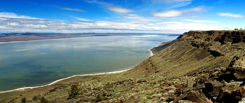
Lake Abert is one of only a handful of hyper-saline lakes in the West. Because of its high salt content, which is up to 7 times higher than seawater, and high pH, due to an abundance of carbonate ions, it has a relatively simple ecosystem of salt- and pH-tolerant species, including brine shrimp (Artemia franciscana) and the alkali shorefly (Ephydra hians).
Lacking fish and having a high productivity, the lake supports invertebrates that are numerous and are the right size to feed hungry waterbirds. Consequently during the summer and fall, numerous migratory waterbirds, including avocets, stilts, phalaropes, sandpipers and grebes, aggregate at the lake to feed on these invertebrates.
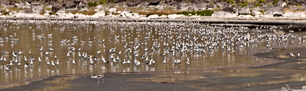
The birds often reach impressively-high concentrations, with single day counts reaching over 300,000 birds.
In 2011, more precipitation and higher inflows brought Lake Abert water levels up and the salinity was within the range (<150 ppt) suitable for a productive ecosystem, but over the next three years, water levels progressively dropped, and in the summer of 2013, salt concentrations reached saturation at 250 ppt and caused most of the ecosystem to collapse.
The 2014 water year brought almost no inflows from the Chewaucan River, the only major source of water to the lake. Flows in the river were low, as they were in rivers region-wide, and what remained was lost due to evaporation and upstream agricultural diversions.
Consequently, the lake reached low water levels not seen in 80 years and as a result was only inches deep and filled only a fraction of its basin. During the summer of 2014, the lake took on a deep burgundy color, never reported before.
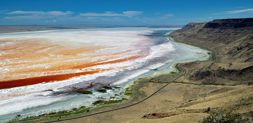
At a salinity of over 250 ppt, only microbes tolerated these conditions and it is believed that the red color was due to the presence of phototrophic haloarchaea, which have a purple pigment known as bactiorhodopsin. Haloarchaea are tolerant of extreme salinities, and thus are called “extremophiles.” Archaea were classified as bacteria, but now are put in a separate domain.
Ongoing studies of water and sediment samples by microbiologists, Wolf Pecher from the Univeristy of Baltimore and Shiladitya DasSarma from the University of Maryland, are helping elucidate the ecological changes that have occurred in the lake owing to the hypersaline conditions.
In 2014, the springs on the east side of Lake Abert flooded an area of lower salinity several square kilometers in size. This lake-within-a-lake was the only area that attracted waterbirds and they were much fewer than in previous years, presumably due to low productivity and reduced habitat availability.
Landsat satellite images taken in 2014 and available at https://landsatlook.usgs.gov, confirmed that other lakes in the region had also become completely desiccated. Only one large lake in the region contained substantial water and that was Malheur Lake in central Oregon. This lake has a substantial inflow from the Donner und Blitzen River coming off of 9,000-foot high Steens Mountain. The river is one of the few in the region that is undepleted by diversions and groundwater pumping.
Lakes in the northwestern Basin and Range have had a long history of wet and dry cycles going back at least thousands of years, and all of them were vastly larger during the pluvial period of the Pleistocene Epoch that ended 10,000 years ago. The largest were Lake Lahontan and Lake Bonneville and that each covered 8,000 and 19,000 miles2 (22,000 and 51,000 km2), respectively.
However, during the current epoch known as the Holocene, which has been drier, the lakes have remained relatively small and many have desiccated completely to become salt flats or playas. These shallow and flat-bottomed lakes are sensitive indicators of climate change because they occur in an arid landscape where evaporation greatly exceeds precipitation. Were it not for the adjacent mountains capturing snowfall, these lakes would not exist under the current climate regime.
Lakes in arid regions are special and provide important ecosystem functions, but world-wide they are under extreme pressure from water diversions and other adverse impacts, and lakes in the northwestern Basin and Range are no exception.
Water management in this region has been, and continues to be, focused on maximizing agricultural uses with much less regard for how it effects the environment. To make conditions worse, some past state and federal funding for environmental restoration has gone to projects that might actually reduce inflows to the lakes. Most of these lakes are not monitored by state or federal water resource agencies. For example, Lake Abert is only currently monitored by volunteers that travel long distances to measure water levels, determine salinity, count waterbirds, and make observations on the presence of invertebrates.
If 2014 is indicative of hydrologic conditions as affected by climate change, the future of lakes in the northwestern Basin and Range is troubling. Were it not for Landsat images of these lakes, most people, including hydrologists, would know nothing about hydrologic conditions of the lakes because of their remote locations and lack of systematic monitoring that we expect of a scarce but essential resource.
In 2012, Oregon developed an integrated water resources strategy that puts greater focus on monitoring and protecting environmental water needs such as instream flows. However, so far there is no visible evidence that this strategy is being implemented in the high desert region of Oregon. Nevertheless, I am hopeful that water-management status quo in this region will change and a greater effort will be made to consider and protect environmental needs.
Ron Larson, PhD
Matthew Landau
Latest posts by Matthew Landau (see all)
- March biology highlights: octopuses, heavy metal, and pocket-sized DNA sequencing - 10th April 2015
- From farm to plate, make food safe! - 7th April 2015
- Dried up! The effects of 2014 on Western US Lake Ecosystems - 13th November 2014
Excellent News!! – ChesterRep to be one of the first to use this function
I ran across this in a Google search, and laughed at the statement that the drying up of Abert Lake is caused by “climate change,” by which I assume to mean anthropogenic global warming. We know that rivers and lakes in southeast Oregon fluctuate wildly, and have been observed in wild fluctuation ever since Europeans began trickling in during the mid- 1800s.
How do we know? Well, in the 1880s and ’90s, the fluctuating water levels in Malheur and Harney Lakes led directly to the land disputes between homesteaders and the famed rancher, Pete French, whose name and that of his backer, Hugh Glenn, is memorialized in the name of the regional town, Frenchglen.
In the 1930s, Abert Lake dried up to the point where a pioneer wagon was exposed, containing the skeleton of a girl murdered by weapons used by the Indians in the 1800s. This tells us that the lake had gone dry at least twice in 80 years — unless you think that the Indians dragged the wagon into the middle of a full lake.
You’re a biologist, and I’ll respect that. But you sure aren’t a historian.
I just drove by Lake Abert on August 21st, 2017 after the Eclipse of 2017 (next day thunderstorm hit this area). Water Level was just below the natural common rim (I could see a tree line about 30 feet from the shore.. max level I guess on the South Eastern Side). There were many birds (20,000 or so) on the Northern side were many springs were adding less salty water. I did not look at the South Side were the river enters for Birds levels. Grass was abundant on the shore. After a 200% snow/rain fall in 2016/2017, it did wonders for this lake. Goose Lake looked lower though… much lower than rim level. Goose lake looked to be receding from the MASSIVE alfalfa production that farmers water 15 hours a day.